
Fontana ZIP Code Coverage
Fontana’s core postal pattern is easiest to read as three delivery zones, not as three municipal wards. ZIP 92335 covers central, south, and east Fontana, including civic, downtown, and industrial areas. ZIP 92336 covers north Fontana, Heritage, Sierra Lakes, and newer northern growth. ZIP 92337 serves Southridge and southern Fontana. Those descriptions orient a lookup. They do not establish a parcel line or a resident list.
| ZIP Code | Areas Covered | Post Office Context | Notes |
|---|---|---|---|
| 92335 | Central, south, and east Fontana; civic, downtown, and industrial areas | Fontana delivery ZIP | Core area; verify the parcel boundary |
| 92336 | North Fontana, Heritage, Sierra Lakes, and newer northern development | North Fontana delivery ZIP | Growth areas require a jurisdiction check |
| 92337 | Southridge and southern Fontana | Southridge delivery ZIP | Near city and county edges |
| 91739 | Rancho Cucamonga and Etiwanda-centered geography with partial Fontana overlap | Neighboring delivery geography | Verify the parcel and city line |
| 92316 | Bloomington-centered geography with partial Fontana overlap | Neighboring delivery geography | Confirm the responsible custodian |
The last two rows are overlapping Census ZCTAs, not extra Fontana wards. USPS does not publish a narrative neighborhood boundary for each ZIP in the researched material. A ZIP code directory can show where an address is routed, while the parcel map and city boundary decide which office holds a permit or code record. The Fontana ZIP code directory is therefore a map of delivery geography, not a count of Fontana households.
Fontana's 91739 and 92316 ZIP Overlaps
The 91739 and 92316 entries matter because postal and Census geography can overlap Fontana without matching its incorporated boundary. A 91739 address may sit in the Rancho Cucamonga or Etiwanda-centered delivery area, while 92316 is tied to Bloomington-centered geography. Research notes that both have partial Fontana overlap, so a ZIP-only conclusion would flatten several jurisdictions into one label. That is the central Fontana postal quirk: the mailing label can stay stable while the responsible land or permit office changes.
Use the overlap as a prompt for a second check. First confirm the mailing result with the USPS address lookup. Then place the parcel in the Fontana public GIS service or the county parcel map. If the question concerns a permit, code case, or business license, the incorporated versus unincorporated line controls the next request.
Note: Overlapping ZIP geography helps find the right address record, but it cannot prove that an owner or occupant belongs to Fontana.
Verify a Fontana ZIP Code
When a mailing label and city line look unexpected, begin with the official USPS address-to-ZIP lookup. The postal result is a delivery check. It does not decide whether a parcel lies inside incorporated Fontana or whether a person occupies that parcel.
The USPS address result is the address-first part of the ZIP code directory workflow.
Open the USPS address-to-ZIP lookup to compare the submitted street, city, state, and returned ZIP before moving to county or city records.
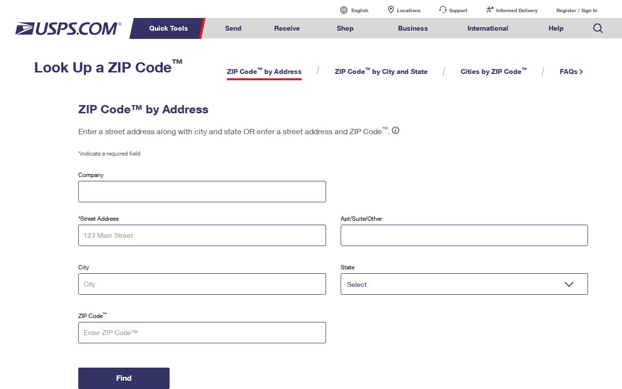
A postal match settles the delivery label used for the address. Parcel jurisdiction, APN, legal description, and permit custody still need their own source check. For a Fontana search, that separation prevents a postal result from being treated as a resident result.
Finding Fontana Residents by ZIP Code
A ZIP can narrow the starting set, but the researched Fontana sources do not provide an unrestricted ZIP-wide resident export. The assessor offers interactive parcel access and says it does not perform special queries. The voter tool verifies a supplied person rather than publishing a browseable street or ZIP roll. A sound search therefore moves from postal validation to parcel review, then to a record-specific request. A Fontana ZIP is a narrowing clue, not a search command for a complete Fontana resident list.
- Check the complete address in the USPS lookup and save the returned ZIP as a delivery clue.
- Use San Bernardino County Assessor Parcel Access or the public GIS map to locate the parcel, APN, situs, and boundary context.
- For a known voter, use the California status form with the required identity inputs. A qualified file request is a separate route and is not open discovery by ZIP.
- Send a permit, code, or business-license request to Fontana when the parcel is incorporated, or to the county when a postal Fontana address is unincorporated.
Once a ZIP narrows the address set to a street, the Fontana street directory approach can follow the parcel and recorded-document chain one address at a time. That street work is more exact than treating the ZIP as a household roll.
Fontana ZIP Filters and Protected Fields
Field names reveal why a ZIP search must not be sold as a complete list of residents. Parcel access is built around an APN, situs, map position, land and improvement characteristics, assessed-value parts, and tax or exemption context. Mailing and situs addresses can differ. The county also protects public owner-address bulk fields under Government Code section 7928.205 and does not advertise a special ZIP-wide owner query. Fontana parcel fields can connect a ZIP check to a county record, but they do not produce a Fontana resident export.
The voter status check is narrower still. The California voter-status lookup asks for a supplied voter’s identity details. Its fields explain the difference between checking a known person and browsing a ZIP.
| Field label | Type | What it does |
|---|---|---|
| First Name | Text, required | Starts a supplied-voter match |
| Last Name | Text, required | Pairs with the identity check |
| Date of Birth | Date, required | Helps verify the named voter |
| California Driver License or ID, or last four SSN | Identity field, tool-dependent | Prevents open browsing |
| Search or Submit | Button | Returns matched status and election services |
Qualified voter-file requests under Elections Code sections 2188 and 2194 use an approved electoral, governmental, scholarly, journalistic, or political purpose. The request route can cover a statewide file or a limited set of known voters, but it does not turn a ZIP into a public neighborhood directory. Driver-license numbers, Social Security numbers, and signatures remain confidential. For Fontana voter work, a supplied name and identity detail are the starting point, not a ZIP browse.
Fontana ZIP Code Edges in GIS
GIS is the bridge between the postal clue and the municipal line. The Fontana public ArcGIS service exposes map layers and query capability, while county Assessor Parcel Access supplies parcel-centered information. Layer fields vary, and the Fontana MapServer advertises a maximum of 1,000 records. That cap is a service limit, not permission to assume a complete ZIP owner list.
Use the map to inspect a known address, see parcel geometry, and compare jurisdiction or district layers. Capture the APN and situs details before asking another custodian for a record. The map can show context around a ZIP edge, but it does not supply a roster of household members. A Fontana GIS query should be read layer by layer.
| Assessor or GIS field | Role | Caution |
|---|---|---|
| APN | County parcel identifier | Links map and assessment systems; it is not a ZIP |
| Situs or map position | Physical parcel location | May differ from the mailing address |
| Land and improvement characteristics | Taxable parcel detail | Does not prove occupancy |
| Assessed-value components | Assessment context | Not a resident count |
| Layer-specific query fields | GIS search or intersection data | Fields vary; the service cap is 1,000 records |
Note: A GIS layer may answer a boundary question while leaving the person question to a separate assessor, court, voter, or city record.
Fontana ZIP Edges Beyond City Limits
Postal Fontana extends beyond incorporated Fontana. City guidance warns that a site using a Fontana mailing address can be in unincorporated county territory. That distinction changes the permit and code path even when the ZIP, city line on a form, and nearby development all look local. Fontana boundary review is therefore part of the records search, not a side note.
For city permits, Building and Safety, Development Services, and Code Compliance are the relevant Fontana channels when the parcel is inside the city. A focused city request can name the address, record series, and date span. For an unincorporated parcel, use the county custodian instead. A business-license result can add address context, but the city warns that its license data is self-reported and does not settle parcel jurisdiction. The Fontana city route and the county route can differ even when the postal label does not.
Boundary rule. A ZIP code tells the mail system where to route an address. Parcel and city-boundary evidence should decide whether Fontana or San Bernardino County holds the next record.
ZIP Code Terms in Plain Words
Postal and Census labels can sound alike while serving different functions. These definitions keep a Fontana ZIP code directory from overstating what a map or lookup can prove. A Fontana user can read each term as a location clue, not as a person record.
- ZIP
- A USPS delivery construct used to route mail. For Fontana, it is not a city ward, parcel boundary, or proof of residency.
- ZIP+4
- An added four-digit postal extension that narrows delivery beyond the five-digit ZIP. It remains a mail-routing detail, not a legal parcel description.
- ZCTA
- A Census statistical geography used to represent ZIP-like areas. The 91739 and 92316 overlaps are ZCTA evidence and should not be treated as city limits.
- Carrier route
- A postal delivery route within a larger ZIP area. No verified Fontana carrier-route table was located, so it should not be used as a local resident count.
Postal Fontana and County Custody
Fontana growth and annexation make address identity a small research problem of its own. A situs address locates the parcel. A mailing address tells an office where correspondence goes. A deed legal description states the land interest. The APN ties county map and tax systems together. None of those labels, by itself, proves who sleeps at a property.
No verified official ZIP polygon, realignment history, or ZIP split year was found in the researched material. No verified street-renumbering year was found either. Historical work should compare old maps, directories, legal descriptions, and parcel clues instead of inventing a date that would make two address strings look continuous.
Annexation can change which government keeps a permit or code file without changing the way mail is routed. The city and its sphere of influence are also different layers. A school-zone finder or district map may answer a service question, but it does not identify occupants. These distinctions matter when a ZIP search moves from orientation to a real records request. The Fontana growth pattern makes that two-layer check especially useful.
The recorder is a separate step from the ZIP. San Bernardino County’s official-record index covers 1925 forward, but it is organized by parties and document identifiers rather than street address. If a parcel question leads to a deed, carry the APN, displayed owner clue, legal description, and date into the grantor-grantee search. Images are inspected at the Hall of Records or High Desert Government Center, or obtained by copy order. A Fontana deed trail therefore begins with a parcel clue rather than a postal number.
When an online route is missing, a focused request under the California Public Records Act can identify an existing city record by series and date range. It cannot require an office to build a new ZIP-wide resident list. A Fontana request should name the record series and date span. This is the practical limit of ZIP granularity in Fontana.
Note: Keep postal routing, parcel evidence, and person-level records as three separate steps whenever a Fontana address sits near a city or county edge.